Mission Statement
To coordinate and provide leadership for activities related to the use of GIS technology within Fort Bend County, Texas and support initiatives to share data, create standards, acquire cost savings through co-op purchasing power and eliminate the duplication of efforts.
History
By resolution of the Commissioners Court of Fort Bend County on the 16th of November, 1999, the Fort Bend GIS Consortium was established to support the geospatial efforts across the county. This resolution recognized the importance of protecting the public by ways of geospatial data-sharing, countywide data standardization, and regular communication between its many, growing public entities. Signed into effect by Judge James C. Adolphus. Click Here to read the Founding Resolution
Current Officers
Chairperson: Bryan Gillis, Katy ISD
Vice Chair: Miriam Salazar, City of Sugarland
Secretary: Penny Hornsby, Fort Bend CAD
Annual Goals
- Foster the creation of open-data portals or data hubs within member organizations;
- Organize professional presentations on geospatial topics;
- Support local GIS educational events and programs
News and Updates
- GeoComm talks School and Public Safety Solutions with Fort Bend GIS Consortium
 Sugar Land City Hall – Cane Room, November 13, 2025 – The Fort Bend GIS Consortium (FBGISC) welcomed GeoComm as the featured presenter for the 2025 4th Quarter meeting. Represented by Mr. Larry Warner and supporting colleagues, GeoComm introduced members to their School Safety Mapping Solution, a modern, GIS-driven approach to improving situational awareness for … Continue reading GeoComm talks School and Public Safety Solutions with Fort Bend GIS Consortium
 - ESRI Presents ArcGIS Solutions to Fort Bend GIS Consortium
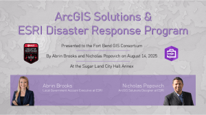 Sugar Land City Hall Annex, August 14, 2025 – Mrs. Abrin Brooks and Mr. Nicholas Popovich presented as representatives of ESRI on the ArcGIS Solutions platform and the ESRI Disaster Response Program to members of the Fort Bend GIS Consortium (FBGISC). ArcGIS Solutions are a collection of free, industry-specific configurations of ArcGIS that can be … Continue reading ESRI Presents ArcGIS Solutions to Fort Bend GIS Consortium
 - LJA Engineering presents to Fort Bend GIS Consortium
 City of Sugar Land Regional Airport, May 15, 2025 – Mr. George Culver, Director of GIS at LJA Engineering (LJA) and the Industry Liaison to the Fort Bend GIS Consortium (FBGISC) presented to members and greater area partners on the leverage of GIS by LJA as the employee-owned company grew from 40 to over 2,000 … Continue reading LJA Engineering presents to Fort Bend GIS Consortium
 - The National Map – USGS presents to FBGISC
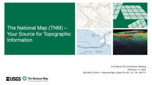 City of Sugar Land – Council Chambers, February 13, 2025 – Ms. Michelle Fischer, National Map Liaison for AR, LA, OK, & TX at the U.S. Geological Survey (USGS) presented to the Fort Bend GIS Consortium on the wide variety of topographic information available through USGS’ National Map. Beyond the data itself, members were briefed … Continue reading The National Map – USGS presents to FBGISC
 - City of Sugar Land Emergency Management & GIS
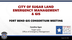 City of Sugar Land – Cane Room, August 20, 2024 – Ms. Caroline Egan, Assistant Emergency Management Coordinator of the City of Sugar Land (COSL), presented to the Fort Bend GIS Consortium and lead a round table discussion on emergency management planning and response. Members were lead through “blue skies1” preparation phases, the unique roles of GIS (as a … Continue reading City of Sugar Land Emergency Management & GIS
